
Introduction:
Photogrammetry software is an extremely versatile tool used in numerous fields ranging from surveys, geology, architecture and archaeology to entertainment industries, for creating 3D models and maps. The process involves extracting exact 3D measurements from two-dimensional photographs or images taken with photogrammetry cameras.
This technology uses triangulation and computer vision principles to analyze images, extract key data points and construct 3D representations of them. Popular photogrammetry software packages such as Autodesk ReCap Photo, Agisoft Metashape and Pix4Dmapper offer solutions tailored to various user requirements and skill levels.
Photogrammetry software features such as point cloud generation, texture mapping and mesh reconstruction are crucial in creating accurate 3D models from images. Photogrammetry software has revolutionized fields like environmental monitoring and urban planning by digitizing real world objects and landscapes with incredible precision and efficiency.
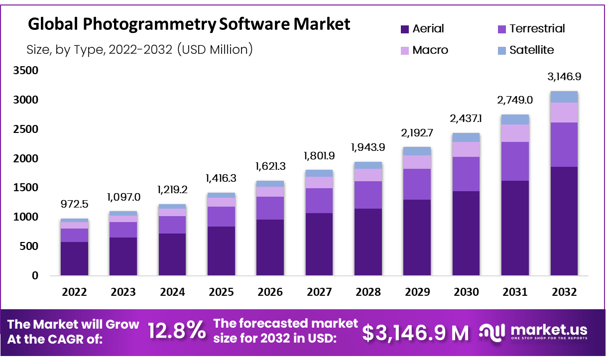
According to market.us Photogrammetry Market size is expected to be worth around USD 3,14.69 Million by 2032 from USD 972.5 Million in 2022, growing at a CAGR of 12.80% during the forecast period from 2023 to 2032.
The 10 Best Photogrammetry Software Companies of 2023
1. Pix4D:
Pix4D, a Swiss company known for their photogrammetry and drone mapping software, specializes in photogrammetry and drone mapping solutions that transform aerial and terrestrial imagery into detailed 3D models and maps for industries such as agriculture, construction and surveying. Their user-friendly interface and powerful processing capabilities have garnered them an excellent reputation in geospatial data processing.
2. RealityCapture:
RealityCapture from Capturing Reality stands out as an advanced photogrammetry software with exceptional speed and efficiency, widely used across industries like gaming, VFX and archaeology where creating detailed 3D models from photographs is integral. Thanks to its automated workflow and advanced algorithms, RealityCapture makes an excellent choice for professionals seeking quality results with minimal manual intervention.
3. Intel RealSense:
Intel RealSense is a division of Intel Corporation specialized in depth sensing technology. Their 3D cameras and software facilitate applications ranging from facial recognition to robotics; providing real-time depth perception of surroundings for autonomous navigation as well as interactive experiences.
4. Skyline Software:
Skyline Software Systems Inc. is best known for their TerraExplorer platform. TerraExplorer facilitates 3D visualization of geospatial data, allowing users to interact and analyze it geographically. Widely employed across fields including urban planning, defense and environmental management it has gained widespread usage among professionals worldwide.
5. Agisoft Metashape:
Agisoft Metashape is an award-winning photogrammetry software used to produce accurate 3D models from photographs. Professionals across disciplines such as archaeology, agriculture and geology depend on it for its powerful reconstruction and processing abilities, guaranteeing detailed output with every shot taken.
6.BAE Systems:
BAE Systems plc is an international defense and aerospace company known for their cutting-edge technologies. Their solutions span across air, land and naval applications including advanced electronics, armored vehicles and cybersecurity solutions - playing an essential role in national security protection as well as military operations around the globe.
7. Photo Mess System:
PMS Photo Mess System AG specializes in developing custom software for photogrammetry and geospatial data processing, offering precise image-based measurements used by industries like engineering and geology. Their solutions can also help users manage spatial databases efficiently.
8. Acute 3D:
Acute 3D provides cutting-edge photogrammetry software. Their products are known for their speed and accuracy, making them indispensable tools in fields such as architecture, surveying and cultural heritage preservation.
9. EyeCue Vision Technologies :
EyeCue Vision Technologies LTD. specializes in computer vision and image recognition technology for use in applications like facial recognition, security monitoring and medical diagnostics - providing innovative tools that enhance visual data analysis.
10. Trimble Inc.:
Trimble Inc. is a global leader in advanced positioning technology, offering solutions for surveying, construction, agriculture and geospatial applications. Their products range from GPS technology to construction software allowing professionals to work more efficiently and accurately within their fields. Their solutions play an essential role in various industries through precise positioning and data collection processes.
Suggested Reading : Global Photogrammetry Software Market By Type (Aerial, Terrestrial, Macro, and Satellite), By Application (3D Printing, Drones & Robots, Films & Games, Topographic Maps, Culture & Museum, and Others), By End-User (Architects, Surveyors, Building & Construction, and Others), By Application, By Region and Companies - Industry Segment Outlook, Market Assessment, Competition Scenario, Trends, and Forecast 2023-2032
Recent Developments:
-
Autodesk Recap Pro now includes an innovative new feature known as "Automatic Model Creation", powered by AI, that automatically generates three dimensional models from point clouds. This can dramatically reduce time and effort required to create three dimensional models.
-
Bentley Systems ContextCapture now includes an innovative feature called Reality Modeling for AEC that is tailored specifically for architecture, engineering and construction industries. This feature contains several tools for creating and managing 3D models of buildings or infrastructure projects.
-
Pix4Dmapper now includes an "AI-powered Point Cloud Classification" feature to classify point clouds automatically into different categories such as ground, vegetation and buildings - providing accurate and detailed 3D models. This new addition can help users create more accurate and realistic 3D models.